Saturday, May 21, 2011

Kings Canyon National Park - May 2011

National Parks are amazing places where exercise is disguised as adventure, and you sneak in some learning too. You expect giant trees and a  huge canyon and you won’t be disappointed.  Yet the whole of these parks is even greater than the sum of its famous parts.

You can see the towering trees along the roadway into Kings Canyon.  “Nature’s peace will flow into you as sunshine flows into trees,” said naturalist John Muir back in 1898.  Just driving into the park you start to get a feeling of being consumed by the massive sizes of the giant sequoias. As you go through this magnificent park some aspects of this special place is likely to stir your interest.

Here is a map of the Grant Tree Loop.  You can walk the ½ mile loop to see amazing features of the Grant Grove.
The General Grant tree at Kings Canyon is the third largest sequoia tree in the world and is estimated to be more than 3,000 years old.  Located in Grant Grove, the General Grant tree was nicknamed the Nation's Christmas tree by President Calvin Coolidge, and remains one of the most popular attractions in Kings Canyon National Park.


The fallen Monarch is a giant fallen Sequoia tree that is hollow inside. You can walk through the tree, and get a feeling for the immense size of these giants. One wonders how long ago this tree fell. A high tannin content make this great sequoia wood indigestible to fungi, bacteria, insects and other decay.  This decay of the wood takes place very slowly.  This fallen Monarch has remained virtually unchanged for well over 100 years and who knows how much longer. 

This is a photo taken from the other side of the fallen Monarch. You can see visitors waiting their chance to walk through the tree.

Look at Kathy standing in front of another fallen sequoia trunk.  You can see how massive the trunk is in size.  No one knows when this tree fell or how long it will take to decay.
Here is a picture of other giant sequoias in the General Grant grove.   As you walk among these gentle giants you get a feeling of amazement.  You are truly in a special place on earth.

Kings Canyon is one of the deepest canyons in the United States.  If you click to enlarge this photo you can see Kings Canyon Lodge which is only open in the summer. 
Grizzly Falls dramatically drops some 75ft and is at its best in spring, when the thunderous force is so strong you can feel the reverberations in your chest.  When the falls' flow diminishes (often to a single narrow column) in late summer, you'll find lots of people frolicking at the base of the waterfall.
 Roaring River Falls will definitely kill you if you fall in anywhere along the way, it’s very powerful. The river is 45 miles (72 km) long and flows south for the first part of its course, then west for the remainder.
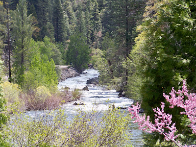
The South Fork Kings River is an important tributary of the Kings River in the U.S. state of California. It joins the Middle Fork Kings River to form the main stem of the Kings. It is famous for flowing through Kings Canyon, a 10,000-foot (3,000 m) deep glacial canyon in the heart of Kings Canyon National Park.
Here's a video of Roaring River Falls.

Friday, May 20, 2011

Sequoia National Park - May 2011

Sequoia National Park is America’s second oldest park, and was created in 1890.  A week later it tripled in size and the Grant National Park was created to protect Grant Grove.  In 1940, General Grant was merged into the newly created Kings Canyon National Park.


In volume of total wood the giant sequoia stands alone as the largest living tree on earth. In the entire world, sequoia grows naturally only on the west slope of the Sierra Nevada, most often between 5,000 – 7,000 feet of elevation.  There are some 75 groves in all.  You can see by this photo how immense the trunk of the trees are relating to the van setting between them.
 Most of the Sierra trees die of disease and fungi, but nothing hurts the big tree.  Barring accidents, it seems to be immortal living in excess of 3000 years old. Chemicals in the wood provide resistance to insects and fungi and thick bark insults them from most fires.  The main cause of deaths is from toppling.  They have a shallow root system with no taproot.  Soil moisture, root damage and strong winds can lead to toppling.
Kathy is standing in front of the Sentinel Tree outside of the giant forrest museum.  The museum details the significance of the big trees and their ecological management.
The General Sherman giant sequoia is the largest living thing on this earth. It stands 275-foot tall.  The trunk weights an estimated 1,385 ton.  If the Sherman tree grew in the middle of the L.A. Freeway it would block three lanes of traffic.  If you laid the tree down on a football field it would extend from one goal line to the opposite nine yard line. 


This is a photo of the base of the General Sherman tree which has a circumference of 103 feet.  If you put the trunk on a scale, it would take more than ten blue whales to balance the scale. 


This photo shows the top of the trees which I had to bend backwards to capture.  Most branches are 8 feet in diameter.
This picture shows us walking up Moro Rock.  Moro Rock is a granite dome with a steep ¼ mile staircase to the summit (300 foot in elevation) and a spectacular view.  There are 400 stairs that lead to the top of the summit at 7625 feet.  The only thing you did not see in this photo is we had to walk the 1.8 mile road to the staircase.  The road was closed to vehicle traffic due to snow plows clearing the road.
This photo is proof that Kathy did indeed make it to the summit.
The soaring peaks of the Great Western Divide separate Sequoia National Park.  The Sierra Crest, which runs along the eastern boundary of the park, includes Mt. Whitney at 14,495 feet, the highest summit in the lower 48 contiguous states.  
This view shows the main road heading up the mountain.  Click on the picture to enlarge and look to the far left you can traffic awaiting its turn to pass through the construction area.

 Here’s a view of the staircase heading back to the parking area.

From this vantage point you catch a glimpse of a mountain wonderland. These Sierra Nevada wild lands contain some of the most speculator scenery on the face of the earth. Jagged peaks drop gently into glacially carved “Yosemite” valleys visited by but a handful of people each year.

 And now for some magic from Kathy.......

Open Sesame!

Close Sesame!  Maybe its not to late to get her on America's Got Talent!

Wednesday, May 4, 2011

Red Rock Canyon - April 2011 - Near Las Vegas, NV

Between a rock and a high place. With more than 2000 climbing routes, Red Rock National Conservation Area is one of the top five climbing destinations in the United States. 


 Why are the rocks red?  More than 600 million years ago, the land that would become Red Rock Canyon was at the bottom of a deep ocean.  The formation, locally known as Aztec Sandstone, is quite hard and forms the cliffs of Red Rock Canyon.

.

 Exposure to the elements caused some of the iron bearing minerals to oxidize.  This oxidizing process can be easily thought of as "rusting the sand," which resulted in red, orange and tan colored rocks.


Calico Hills offers access to sport climbing areas and the best close up views of Calico Hills.


Although you can see most of Red Rock Canyon by driving the 13-mile scenic route, no trip would be complete without a nice hike.  Kathy (she says it was me) suggested we take the most strenuous hike within the park.  Look in the center of the photo and you can see some people rock scrambling the final mile to the top of the peak.


 Turtlehead Peak is a 5-mile round-trip, 2000 foot, mostly rock scrambling climb to the top of the peak.  Here I am looking over the peak while Kathy is documenting our hike in the visitor log. It took us 2 hours and 15 minutes to walk and mostly climb our way to the top. My hat is reversed due to the 45 mph winds at the top of the peak. I did not want to get to close to the edge in fear that the wind might gust and I would be airborne without a parachute.


Enlarge this photo and you should be able to see Las Vegas in the background. You can literally sit on the edge and swing your feet over the peak.  No way. No how.


The hike back down was very steep with a lot of loose gravel.  It took us just over one hour to cover the 2 1/2 mile return trip.  I decided it was time for new hiking boots after this journey.  We both wished we still had a hot tub to ease our pains.
This is Turtlehead Peak.  What were we thinking?


Pulling up Anchor at Acadia National Park

 I thought it would be nice to add a few facts about Acadia National in each of the photos below. We decided that our last trip here at Acad...