Tuesday, May 25, 2021

Cathedral Rock Trail - Mt Charleston NV


Cathedral Rock Trail is a 2.8 mile heavily trafficked out and back trail located near Las Vegas, Nevada that features a great forest setting and is rated as moderate.


From the signed trailhead the trail starts in a westward direction at a slight grade. It winds through thick patches of aspens and evergreens before passing by the alternative trail. The trail turns south and heads toward the magnificent Echo Cliffs.


The trail features a great forest setting and is rated as moderate.


The Cliffs have a sheer drop of almost 1,000 feet.


The trail is a continuous and strenuous uphill, so bring enough water and snack. Keep your pace steady, and you will enjoy what the Cathedral rock has to offer.


The temperature was perfect and almost cold at the top. you can see the Mt. Charleston from the top as well.


Great trail—poles are helpful.


The aspens are beautiful on the hike up and the view at the top is rewarding.


Very doable, with shaded areas and vast overlooks.


The last bit has some steep elevation but the reveal at the top is worth it. This is a photo of the town of Mt. Charleston.


Enjoyed a Banana Nut Muffin and a well deserved rest before heading back. 


We finally reached the top of the hike and took every moment to soak in the amazing views. 


Great place to hang out for a bit at the top. We stopped for about 30 minutes and talked with fellow hikers from Chattanooga TN.


This was our last training hike before our rafting trip begins on Saturday.  


If you’re not from the area or not used to higher elevations it will have a bigger impact on your breathing rate than you would expect so just take your time.


These screen shots are from a program called "Map your Walk" by Under Armor.  We are using the free version. Outstanding program, Very helpful for keeping yourself on trail. 


Mary Jane Falls Trail - Mt Charleston NV


Mary Jane Falls Trail is a 2.5 mile heavily trafficked out and back trail located near Mount Charleston, Nevada that features a waterfall and is rated as moderate.


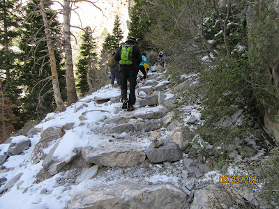
Some tall rock steps and lots of loose rocks so folks with knee problems should bring poles.

\

Biggest plus is how much cooler it is up here!


It had snowed the day before our hike,  


Nice views of the canyon walls throughout the hike.


This hike was definitely fun and boasted excellent views!


The trail itself is actually kind of a mess though with the switchbacks crumbling due to many hikers going off trial.


Plenty of people on the trail and did need to step aside to allow others to pass on the switchbacks.


The fall was a steady trickle but not much of a waterfall at this time.


Kathy on the way back down,  My favorite part of the hikes. 


A nice, moderate hike that was challenging at first because of the elevation.  All in all, a very good training hike for our upcoming rafting trip. 


Wednesday, May 19, 2021

Flagstaff to Sedona AZ


You start out up in the lush rugged forests of Flagstaff and work your way down (in direction (south) and in elevation) to the canyon and rock formation


The higher regions of the canyon display forests full of Aspens, Oaks and Maples.


You need to keep an eye out for rocks falling on the road.


You want to look up at the beautiful formations but keep your eyes on the road. 


The closer you get to Sedona the more red rocks appear. 


Talk about scenery sensory overload.


This is an aerial shot that I found on-line of the switchbacks along the route. Speed of turns range from 15-20 MPH.


This road can have some awesome switch backs and steep ascents/descents.


A great 35-mile ride.  We stopped at a local Mickey D's for a cinnamon roll and milk.  


Monday, May 17, 2021

South Piedra Lisa Trail


Kathy took a photo of the trail route but we did not need it. She has an App on her phone called "Map my Walk" which as long as you have phone connectivity, it shows you your route and your location. It also showed elevation, distance and time.


Piedra Lisa, we think means (Smooth Stone) Trail marker. Trail follows the hillside around to the north before entering a canyon and climbing, nearly constantly, to the saddle at 2.2 miles.


The trail is well maintained and easy to follow with wonderful views throughout.


As with other hikes in the area, the start follows some very nice houses along the route.


Steep but us sea level east coast seniors pushed through with some stops along the way! Great vistas!!!!


Excellent moderate hike. Well maintained trail with great views of Sandia Crest.


Remember the great views!


The payoff is worth the scramble up to the summit for the panoramic view.


You never know what's in the photo till you view the shot.  Kathy did an excellent job catching a bird in fight.  


It gets a little confusing as to where you're supposed to go at the T-junction at the top, but just find a place and enjoy the view!

Tramway Trail Hike


The Tramway trail is a 5
mile heavily trafficked out and back. It offers great views of the lower Sandia
Mountains on the eastern slope.


The trail begins near the Tram parking lot and is marked by this metal post. You have to pay $3 for parking to get close to the trailhead.


                     You can see the Tram building in the center of this photo.


Even in the desert, you can see beauty.  


Don't expect much wilderness; you can see the houses not far below you for most of the trail.


The trail is fairly normal until you get the the last mile of the hike.


The last mile goes steeply uphill which was a good workout for both of us. 


The trail was full of other hikers.
It has nice varied terrain, wildlife, shade trees, and great views of ABQ and the tram. Plus it's not very busy, so it was much quieter.


This was a pleasant trail with nice views. Most of the trail is mellow, except for a few steep rocky parts during the last part of the trail. It does reward you with great views of Albuquerque.


Pulling up Anchor at Acadia National Park

 I thought it would be nice to add a few facts about Acadia National in each of the photos below. We decided that our last trip here at Acad...