Friday, May 20, 2011

Sequoia National Park - May 2011

Sequoia National Park is America’s second oldest park, and was created in 1890.  A week later it tripled in size and the Grant National Park was created to protect Grant Grove.  In 1940, General Grant was merged into the newly created Kings Canyon National Park.


In volume of total wood the giant sequoia stands alone as the largest living tree on earth. In the entire world, sequoia grows naturally only on the west slope of the Sierra Nevada, most often between 5,000 – 7,000 feet of elevation.  There are some 75 groves in all.  You can see by this photo how immense the trunk of the trees are relating to the van setting between them.
 Most of the Sierra trees die of disease and fungi, but nothing hurts the big tree.  Barring accidents, it seems to be immortal living in excess of 3000 years old. Chemicals in the wood provide resistance to insects and fungi and thick bark insults them from most fires.  The main cause of deaths is from toppling.  They have a shallow root system with no taproot.  Soil moisture, root damage and strong winds can lead to toppling.
Kathy is standing in front of the Sentinel Tree outside of the giant forrest museum.  The museum details the significance of the big trees and their ecological management.
The General Sherman giant sequoia is the largest living thing on this earth. It stands 275-foot tall.  The trunk weights an estimated 1,385 ton.  If the Sherman tree grew in the middle of the L.A. Freeway it would block three lanes of traffic.  If you laid the tree down on a football field it would extend from one goal line to the opposite nine yard line. 


This is a photo of the base of the General Sherman tree which has a circumference of 103 feet.  If you put the trunk on a scale, it would take more than ten blue whales to balance the scale. 


This photo shows the top of the trees which I had to bend backwards to capture.  Most branches are 8 feet in diameter.
This picture shows us walking up Moro Rock.  Moro Rock is a granite dome with a steep ¼ mile staircase to the summit (300 foot in elevation) and a spectacular view.  There are 400 stairs that lead to the top of the summit at 7625 feet.  The only thing you did not see in this photo is we had to walk the 1.8 mile road to the staircase.  The road was closed to vehicle traffic due to snow plows clearing the road.
This photo is proof that Kathy did indeed make it to the summit.
The soaring peaks of the Great Western Divide separate Sequoia National Park.  The Sierra Crest, which runs along the eastern boundary of the park, includes Mt. Whitney at 14,495 feet, the highest summit in the lower 48 contiguous states.  
This view shows the main road heading up the mountain.  Click on the picture to enlarge and look to the far left you can traffic awaiting its turn to pass through the construction area.

 Here’s a view of the staircase heading back to the parking area.

From this vantage point you catch a glimpse of a mountain wonderland. These Sierra Nevada wild lands contain some of the most speculator scenery on the face of the earth. Jagged peaks drop gently into glacially carved “Yosemite” valleys visited by but a handful of people each year.

 And now for some magic from Kathy.......

Open Sesame!

Close Sesame!  Maybe its not to late to get her on America's Got Talent!

Wednesday, May 4, 2011

Red Rock Canyon - April 2011 - Near Las Vegas, NV

Between a rock and a high place. With more than 2000 climbing routes, Red Rock National Conservation Area is one of the top five climbing destinations in the United States. 


 Why are the rocks red?  More than 600 million years ago, the land that would become Red Rock Canyon was at the bottom of a deep ocean.  The formation, locally known as Aztec Sandstone, is quite hard and forms the cliffs of Red Rock Canyon.

.

 Exposure to the elements caused some of the iron bearing minerals to oxidize.  This oxidizing process can be easily thought of as "rusting the sand," which resulted in red, orange and tan colored rocks.


Calico Hills offers access to sport climbing areas and the best close up views of Calico Hills.


Although you can see most of Red Rock Canyon by driving the 13-mile scenic route, no trip would be complete without a nice hike.  Kathy (she says it was me) suggested we take the most strenuous hike within the park.  Look in the center of the photo and you can see some people rock scrambling the final mile to the top of the peak.


 Turtlehead Peak is a 5-mile round-trip, 2000 foot, mostly rock scrambling climb to the top of the peak.  Here I am looking over the peak while Kathy is documenting our hike in the visitor log. It took us 2 hours and 15 minutes to walk and mostly climb our way to the top. My hat is reversed due to the 45 mph winds at the top of the peak. I did not want to get to close to the edge in fear that the wind might gust and I would be airborne without a parachute.


Enlarge this photo and you should be able to see Las Vegas in the background. You can literally sit on the edge and swing your feet over the peak.  No way. No how.


The hike back down was very steep with a lot of loose gravel.  It took us just over one hour to cover the 2 1/2 mile return trip.  I decided it was time for new hiking boots after this journey.  We both wished we still had a hot tub to ease our pains.
This is Turtlehead Peak.  What were we thinking?


Sunday, April 24, 2011

Death Valley National Park - April 2011

 A fellow visitor was kind enough to take our photo at the entrance to Death Valley National Park. 
Zabriskie Point.  Surrounded by a maze of wildly eroded and vibrantly colored badlands, this spectacular view is one of parks most famous.  This viewpoint is a short walk uphill from the parking area.
Polished marble walls and odd mosaic patterns of breccia make Mosaic Canyon a favorite hike.
This is a popular 2 mile, one-way hike.  The twisting lower canyon is so narrow hikers must walk through it single file.  

Move over Superman!  Here's Kathy holding up a huge rock.  All our hard work at the gym has paid off. She is also available to move furniture. 

Dante's View. The most breath taking viewpoint in the park, this mountain-top overlook is more than 5000 feet above the inferno of Death Valley.  The white area in the photo is Badwater Basin a surreal landscape of vast salt flats.
In this close up photo, if you did not know the white area was Badwater Basin, one might think its clouds.
Dave entering Golden Canyon.  We are hiking the Gower Gulch Loop, a 4-mile round trip.  The trail follows colorful badlands, canyon narrows, and old borax mines.

Here's Kathy standing below Red Cathedral located 1/4 mile up the canyon,
I think Kathy is telling me to go this way.  We are at marker #10 identifying the trail to Gower Gulch, a 2.3 mile hike down the gulch to finish the loop.

Here's our last challenge to get out of the Gulch.  Looks simple, but it's the top of a 25-foot dry falls.    Lucky for us there was an alternate route around the falls,  a narrow path that leads back to the parking area.
Lowest point in North America. 
Here's Kathy standing in the middle of the basin.  The Basin is 5-miles wide and you can walk the entire distance, not recommended since temperatures can exceed 130 degrees fahrenheit in July.   

They say a picture is worth a thousand words.  Dave is holding our Garmin Etrex GPS.  You can see that the elevation is showing -282 feet. 

Thursday, April 7, 2011

Las Vegas Motorcoach Resort - March/April 2011

Welcome to Las Vegas Motorcoach Resort where swimming pools, tennis courts, nine-hole putting greens and a luxurious clubhouse come standard.  It does not hurt to have 5 hot tubs either! We arrived here on March 30th and we're parked on lot #389 owned by Rick, a friend of Bob Ulin who is our host.
We met Bob and Sandy two years ago during our visit to Admiral Baker Golf Course and RV Facility in San Diego.  Bob and Sandy live in Anchorage Alaska.  We stopped by for a short visit to see them during our Alaska trip during the summer of 2009. 
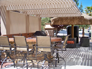
This is an exceptional lot with great landscaping and a beautiful outside kitchen and lounge area. It really looks good with our motor home parked in it. 
The outside kitchen is nicely equipped with a grill, 2-burner stove top, ice maker and 2 refrigerators.  The palapa in the rear also includes a fire place to keep you warm and toasty during those chilly Vegas nights.

Here's a photo of Bob & Sandy's lot around the corner.

Here's Bob in his vintage golf cart replica of a 1932 Ford pick up. I am making a custom cover out of Sunbrella for storage when they head back to Alaska for the summer months. We are planning to depart the resort on April 19th. 

In addition to the custom golf cart cover, I created custom wheel covers for Bob.  He said he was tired of bending to install his old ones.  The new ones easily attach via snaps to the outside of the RV.  I included a slot on the bottom of the covers to accommodate some metal stock from Home Depot to keep the covers from blustering during windy conditions.

Here's a picture of a cover I made for his 2-burner stove top.  It will help keep debris out of the burner tray. I can't think of anything else that I need to make a cover for so I guess it might be time to hit the road again!

Pulling up Anchor at Acadia National Park

 I thought it would be nice to add a few facts about Acadia National in each of the photos below. We decided that our last trip here at Acad...