Thursday, June 9, 2016

Grandson Graduation Video

The below video is dedicated to our grandson Ryan who just graduated from Eastern Technical High School.  


The Marquee photo. 


Ryan watching the proceedings. 


The 2016 graduate.


Ryan and his Mom.


Ryan and his very proud grandparents.

That diploma you hold in your hands today is really just your learner’s permit for the rest of the drive through life. Remember, you don’t have to be smarter than the next person, all you have to do is be willing to work harder than the next person.

Click arrow to start presentation. Click box in lower right corner to access full screen.


Sunday, January 31, 2016

Quartzsite 2016


Quartzsite AZ is the mecca for winter snowbirds in the southwest. Located about 15 miles east of the California and Arizona border, this tiny town surrounded by a vast desert landscape is where thousands of RVers flock together every January and February. If you’ve never been to Quartzsite, home to the world’s largest RV rally, you really need to put this on your RV "To DO" list. 


Here's the IRV2 Monaco Group located at La Posa South (BLM) about 4 miles south of the big tent.  Although most RV's are Monaco many others friends join this group for their annual get together.  


We arrived from Laughlin NV (Riverside Casino) on Jan 13th along with Mike and Sharon.  Our friends, Rick and Mic, arrived from Phoenix AZ the same day as well.  Here we are set up in La Posa South BLM land. We are staying with the Monaco IRV2 owners group.  You pay $40 to camp here for 14 days.  We liked this area because it is equipped with trash dumpsters,  RV dump and a fresh water station. 


Quartzsite is a great place to get your rig in prime condition for the rest of the snowbird season and beyond. That’s because manufacturers know that the annual gathering is an easy way to showcase their RV goods and services to thousands of RVers, all camped out in one location.   Mike, referred to as "Drifter" by the group, installs a gas strut on the front door of our coach.  Mike will literately drill a hole into anything.  Monaco uses a metal scissor arm which needs to be realigned or replaced every six months to a year. 


Here is a photo of the completed install.  The strut is a 20 pound gas strut secured by two  mounting brackets.  Not only does it work perfectly, it eliminated the door noise we experienced while driving our rig over bumpy roads and ruts.  Thank You Drifter for a job well done!  In addition to the door strut, we installed a hard wired cable the length of the coach for rear-view camera.  I also completed many other RV repairs that needed attention.  My thanks to the many friends who assisted my efforts. 


Fifty-Five coaches attended the annual event.  Kathy and I had a great time seeing old friends and meeting many new ones.  We look forward to our return in the future. 


After having dinner at a local establishment, the group sets around a huge camp fire every night and discusses the days activities. 


Here's a look at a rig taking on water.  Notice the solar panel atop the roof.  RV's use solar energy to charge their batteries and reduce generator time.  Solar is a must for anyone that dry camps on a regular basis. 


Here another group of RVers 1/2 mile down the road from our location. This group consists of conversion Buses, Bluebirds and  Wander Lodge coaches.  


Here's our new Winegard Traveler Satellite Dish.   The dish is High Definition  (HD) capable and we can now record two shows on each of our receivers.  HD is definitely the way to go!  The unit is automatic when turned on and takes about 8-10 minutes to locate the Direct TV satellites. 


Kathy and I were selected to receive a free Magne Shade from Amazon to help advertise their Amazon Camperforce Program.  All they ask is for us to display the shade at campgrounds and rallies. Kathy already signed up one person to work at Campbellsville KY SDF-1 facility next year.  She is also still working on getting me to return for year 5.


The get together is not complete without Kathy's freshly made doughnuts. This is one of the highlights of the trip. You can't eat just one!


Here's one of the many fantastic sunsets we enjoyed during our stay. 


Another great sunset.


We also had a full moon on the night before we departed.  This photo was taken on the morning we departed.  The weather was excellent during our stay. 


A look at the final sunrise prior to leaving.  We say good-bye and safe travels to our friends. 


Tuesday, June 9, 2015

Great Sands National Park - Colorado


A sandbox of epic proportions, the entire dune field encompasses 30 square miles.


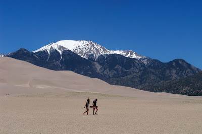
The park contains the tallest sand dunes in North America, rising about 750 feet from the floor of the San Luis Valley on the western base of the Sangre de Cristo Range, covering about 19,000 acres. 


One of the most unusual features of the park happens at Medano Creek, which borders the east side of the dunes and is located next to the Visitor Center.  Because fresh sand continually falls in the creek, Medano Creek never finds a permanent and stable streambed. Small underwater sand dunes that act like dams continually form and break down, and so waders in the stream see surges—which look like waves—of water flowing downstream at intervals of anywhere from just a few seconds to a minute or more.


Here a couple walks towards Medano Creek with snow still atop the mountain in the background.  In summer, mid-day sand surface temperatures can soar to 150 F but average daytime highs are only in the 80's.  


Hiking the dunes is a favorite past time for visitors. Hiking to the top is about 3-miles long and hikers will be rewarded with great views.


The other favorite past time is surfing the dunes.  You can rent boards at most of the local campgrounds. 


The dunes were formed from sand and soil deposits of the Rio Grande and its tributaries, flowing through the San Luis Valley. Over the ages, glaciers feeding the river and the vast lake that existed upon the valley melted, and the waters evaporated.

Sand Ramp Trail Hike 


Begin hiking the Sand Ramp Trail in Loop 2 of the campground.


Most of the trail is naturally sand.  


You cross the creek a couple of times during the hike. 


This marker indicates the direction to the Dunes Overlook and Point of No Return. 


The views of the Dunes are impressive.


We didn't hike up into the Dunes but if you do, it is recommended that you hike the ridge of the dunes to make the hike easier. 


Here you can see Medano Creek located on the East side of the Dunes.  

Sometimes we are lucky and capture the true meaning of Natures Beauty.  These photos were taken at the park during sunset.  


Looking West. 


This photo was taken the evening before we departed.  I looked outside and the sun was reflecting on the hillside. 

Thursday, June 4, 2015

Monument Valley Navajo Tribal Park - Wild Cat Trail


The Wildcat Trail is the only hiking trail inside the Tribal Park that visitors can hike unescorted by authorized Navajo guides.


The Wildcat Trail begins just past the Navajo Tribal Park visitor center by the edge of a large, flat parking area at the edge of an escarpment.


The first part of the path winds a few hundred feet down a gently sloping hillside towards West Mitten Butte, about one mile away.


 A mile or two further, and to the left are the wider cliffs of Sentinel Mesa, while the horizon in the far distance is largely featureless.


The Trail allows for inspection of this rock from all angles, even if the surrounding landscape looks similar all along the one to two hour journey.


Merrick Butte rises ever more prominently ahead as the path curves around the West Mitten Butte, revealing its top to be a thin narrow ridge rather than the wide, rounded peak that appears from the south, the normal viewing angle.


On the far side, the trail runs for a while along a larger dry wash, then soon turns back northwest, now over even flatter ground that gives the first good view of a group of little-visited rocks to the north, including Big Indian, Saddleback and Castle Butte. These are several miles away, but rather closer is the tall span of Sentinel Mesa that comes into view directly ahead.


The hikes continues along a stream bed as you begin your return trip,


The toughest part of the return hike is along the hilly portion of sand.  You really work your legs to get up the 10-15 percent grade. 


We hiked the 4-mile trail at 24 minutes per mile.  We used Kathy's phone app to track our progress. 
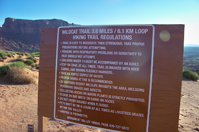

The hike is completed by a walk along a short climb back to the trail junction, from where the starting point is a little way further up the hill.


Pulling up Anchor at Acadia National Park

 I thought it would be nice to add a few facts about Acadia National in each of the photos below. We decided that our last trip here at Acad...