Saturday, June 12, 2021

Grand Canyon Rafting Trip Day 2


Morning call for coffee and juice.  For breakfast we had pancakes, bacon and fruit.   Last night we decided to sleep without our tent under the beautiful stars.  I tried to get a nighttime video of the stars but was unsuccessful.  


Our first stop "Red wall Cavern".  The below video provides a better glimpse of this huge cavern.  


Our dry bags are attached to a nylon line for security.  We wear river shoes for entering the raft.  These shoes have excellent grip for walking on rubber but when sand is on the bottom of your shoe you must be extra careful when entering or exiting the raft. 


Our motorized C-Craft raft design has a lower than usual center of gravity, 64,000 pounds of buoyancy, and a special articulating frame system that holds everything in place, but also allows the boat to absorb the river’s energy.  


You see many other rafting vendors during your trip down the canyon.  Some of the smaller rafts take 14-days to travel the 226 mile venture.  


It's amazing to see how much greenery and animals live and thrive in the Grand Canyon. The Hopi Indians were one of the first to live in the canyon. The 6 tribes generally associated with the Grand Canyon are the Hualapai, Havasupai, Navajo, Hopi, Paiute and Zuni. Each of these tribes have resided on the Colorado Plateau long before the arrival of Europeans and each has their own unique culture and heritage as well as a common connection with the Grand Canyon.


The canyon is specular to see from any direction.  That's  "Will" our Trip Leader and pilot.  He provided great details about the canyon formation and people who led early expeditions of the canyon.  He studied Geology in college and was very knowledgeable of rock formations along the Grand Canyon.  


Remember I mentioned in Day 1, how shallow the water level is in the canyon.  Notice in this video Todd, my personnel Cardiologist, who was also on trip is pointing at a rock that normally you would not see during the trip.  


Friday, June 11, 2021

Grand Canyon Raft Trip Day 1 - "Our Journey Begins"


We departed Flagstaff AZ, for a 2 hour plus bus trip to our departure point at Lee's Ferry. This is the very start of the Grand Canyon, where adventurous river runners launch their boats for trips down the canyon.


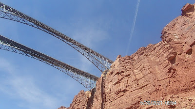
Those traveling across the country on Highway 89A between Bitter Springs and Jacob Lake, AZ arrive at two bridges similar in appearance spanning the Colorado River. These two bridges, one historic and one new, represent one of only seven land crossings of the Colorado River for 750 miles. 


We finally arrive at Lee's Ferry our departure point. The two boats directly in front of of the orange life preservers belong to Canyoneers Grand Canyon Adventurers, our host for our 8-day journey


We all have our yellow day-bags which contain our personnel items for each day of our trip. Each night/morning we load items such as sun block, extra clothing, camera etc, for daily use. The bags are always available and secured each day.


We fit and adjusted our life preservers which must be worn at all times when in the raft.  The canyon water temperature is between 46-50 degrees throughout our trip. The life preservers must be fitted properly in case someone would fall into the water.  We would use the person to person hold and pull to assist lifting an individual from the water,    If the preserver is not fitted properly, we would pull the person right out of the preserver. 


Remember the bridges in the earlier photo, this is what they look like from below. The oldest bridge is called the Navajo Bridge. The Navajo Bridge served the area well for 66 years. However, as automobiles and trucks became larger, wider, and heavier, the need for a stronger, wider bridge became evident.


Ahead is Paria Riffle, mile one, our first look at white water.  This is a very mild rapid.  The rapids in the Grand Canyon are numbered 1-10.  Ten being the most difficult to navigate by the pilot.  The water level in the canyon is extremely low and very hazardous at this time.  


The canyon walls are magnificent in both beauty and height. Nearly 40 identified rock layers form the Grand Canyon’s walls. The story of how Grand Canyon came to be begins with the formation of the layers and layers of rock that the canyon winds through. The story begins about 2 billion years ago.


When watching videos, click bottom right [  ] to expand video to full screen mode. 
After successfully navigating House Wall Rapid, rated 9.8,7.7., we watch our sister raft encounter the rapid.    


Kathy and I decided to sit up front to experience the rapids for ourselves.  Yes, the water is damn cold!


Mile 20:  We hiked one mile up-canyon, scrambling over boulders, to reach a stream where pools are carved into the slick rock. During times of plentiful precipitation, the stream transforms into water slides dropping into plunge pools.   


Unfortunately, the water levels in the canyon were very low and we did not get a chance to experience the water slide. 
 

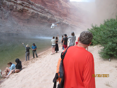
Our first day in the canyon ended with a Medevac rescue of one of our members.  There was not major medical event.  Our Trip Leader determined he was not physically capable of proceeding.  The Grand Canyon has on average 300 rescues per year.  


The helicopter landed 10 feet from our projected tent site. All gear had to be relocated to ensure it was not blown away.  We had dinner in the dark about 9 p.m.   We slept without our tent the first night under the stars.  Although the stars were unbelievable, neither of us slept well. 

Note:  Some of the  date stamps on the photos are not correct.  When you change the camera battery, you have to reset the date stamp.  My mistake. 
 

End of Day 1 

Tuesday, May 25, 2021

Cathedral Rock Trail - Mt Charleston NV


Cathedral Rock Trail is a 2.8 mile heavily trafficked out and back trail located near Las Vegas, Nevada that features a great forest setting and is rated as moderate.


From the signed trailhead the trail starts in a westward direction at a slight grade. It winds through thick patches of aspens and evergreens before passing by the alternative trail. The trail turns south and heads toward the magnificent Echo Cliffs.


The trail features a great forest setting and is rated as moderate.


The Cliffs have a sheer drop of almost 1,000 feet.


The trail is a continuous and strenuous uphill, so bring enough water and snack. Keep your pace steady, and you will enjoy what the Cathedral rock has to offer.


The temperature was perfect and almost cold at the top. you can see the Mt. Charleston from the top as well.


Great trail—poles are helpful.


The aspens are beautiful on the hike up and the view at the top is rewarding.


Very doable, with shaded areas and vast overlooks.


The last bit has some steep elevation but the reveal at the top is worth it. This is a photo of the town of Mt. Charleston.


Enjoyed a Banana Nut Muffin and a well deserved rest before heading back. 


We finally reached the top of the hike and took every moment to soak in the amazing views. 


Great place to hang out for a bit at the top. We stopped for about 30 minutes and talked with fellow hikers from Chattanooga TN.


This was our last training hike before our rafting trip begins on Saturday.  


If you’re not from the area or not used to higher elevations it will have a bigger impact on your breathing rate than you would expect so just take your time.


These screen shots are from a program called "Map your Walk" by Under Armor.  We are using the free version. Outstanding program, Very helpful for keeping yourself on trail. 


Mary Jane Falls Trail - Mt Charleston NV


Mary Jane Falls Trail is a 2.5 mile heavily trafficked out and back trail located near Mount Charleston, Nevada that features a waterfall and is rated as moderate.


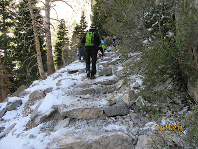
Some tall rock steps and lots of loose rocks so folks with knee problems should bring poles.

\

Biggest plus is how much cooler it is up here!


It had snowed the day before our hike,  


Nice views of the canyon walls throughout the hike.


This hike was definitely fun and boasted excellent views!


The trail itself is actually kind of a mess though with the switchbacks crumbling due to many hikers going off trial.


Plenty of people on the trail and did need to step aside to allow others to pass on the switchbacks.


The fall was a steady trickle but not much of a waterfall at this time.


Kathy on the way back down,  My favorite part of the hikes. 


A nice, moderate hike that was challenging at first because of the elevation.  All in all, a very good training hike for our upcoming rafting trip. 


Pulling up Anchor at Acadia National Park

 I thought it would be nice to add a few facts about Acadia National in each of the photos below. We decided that our last trip here at Acad...