Friday, April 12, 2013

Bright Angel Trail Hike


To get the best views of the canyon its best to hike down the South Kaibab Trail and return via the Bright Angel Trail.  There are two main reasons its one of the earliest trails from the South Rim: water and accessibility.  The springs at Indian Gardens produce more potable water than others along the south side of the canyon, and the Bright Angel Trail Fault creates a natural break in the cliffs, making it easy to reach Indian Gardens.


Donna takes one more look at Phantom Ranch before she heads out on her return trip.  The trails begins along the river which is not as easy as one might suggest.  The Trail makes a couple of fairly steeps ascents and descents along the way and walking across some of the dune sections with a full pack can be difficult.  We can all attest to that.  


This video shows us hiking the dune section of the river trail.  The trail along the river runs for 1.7 miles before it starts to head upward towards the South Rim. 


The trail follows along a stream and you cross the stream 4 times at different locations.  Each location provides its own difficulty in crossing.  The hiker utilizes large rocks and hiking sticks to aid them in crossing.  One wrong move and you and your feet could be wet.  


Here's a video of Kathy and Donna at one of the stream crossings.  Are you sure your shoes are water proof?


Kathy and Donna take a well deserve rest at Indian Gardens.   Indian Gardens is considered the half way point of the return hike.  Get some rest, eat and drink plenty of water.  Only 4.5 miles to go!


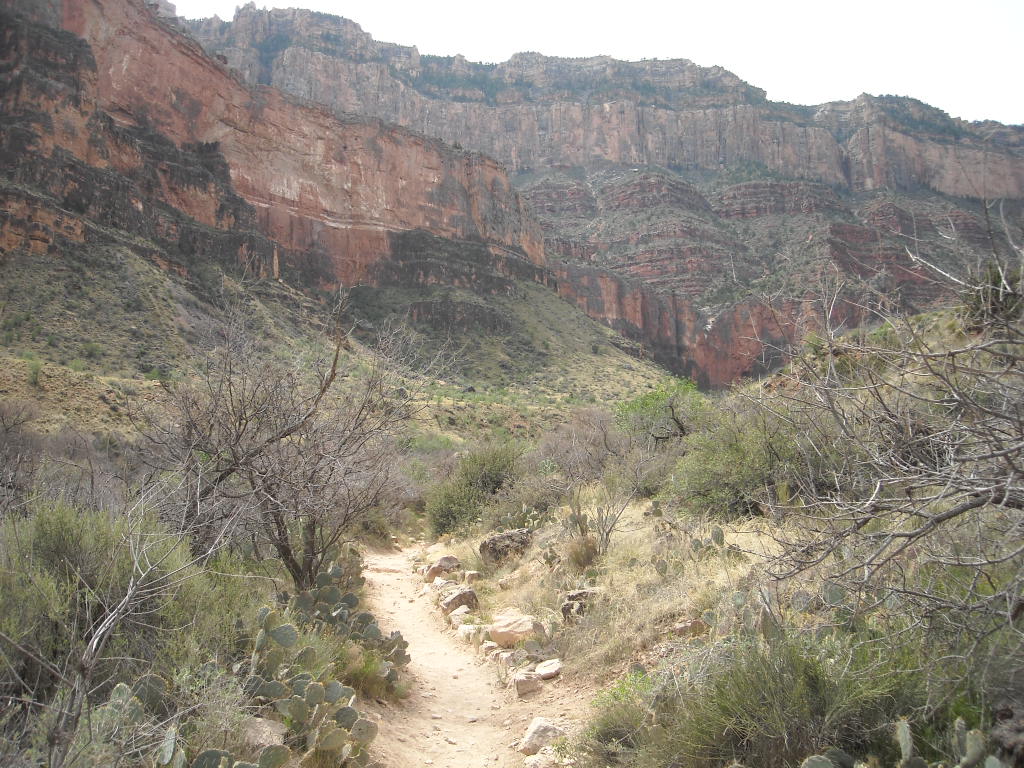
This is an excellent photo showing some of the trail leading out of Indian Gardens.  You have about 1.5 miles to get to the 3-mile rest house.  


You can see hikers walking along the switch backs leading up the canyon.  This starts the steepest part of the return hike.  The hiker gains 1000-foot in elevation per mile for the last 3 miles of the hike.  Remember, the hiker traveled 7 miles before starting the final ascent of the journey. 


Doyle and Judy take a rest during the last 1.5 mile hike up to the rim.  


Judy and Doyle cross the finish line.  You can see by Judy's smile she is glad its over.  You can also see that they are doing some renovations at the trail head.  


The group having a well deserved meal.  Afterwards, we opened a couple bottles of wine at the coach and viewed all the photos and videos documenting our journey.  The trip was wonderful and we all will have great memories of our time together.  A special thanks to Kathy for all the repeated phone calls and coordination to make this "expedition" as Doyle calls it, a special memory.  


Here's the final stats regarding our hike.  If you have trouble reading data, just click on the photo to enlarge it.  

Thursday, April 11, 2013

Phantom Ranch


Phantom Ranch continues to be one of the most popular destinations in the National Parks system; its accommodations are often sold out a year in advance.  The Ranch now includes cabins, two dormitories one for men and one for women, a restaurant, a mule corral, emergency medical facilities, a ranger station and the Bright Angel Trail Campground along with a heliport.


The restaurant serves only meals that are booked in advanced. Dinner meals are served at 5 (Steak Dinner) and 6:30 p.m. (Beef Stew) respectively. Hikers can also purchase sack lunches in advance.  This is also the only location in the U.S. that the all mail is still taken out by mules.  


Cabins are available for the mule riders.  Hikers can call the night prior your hike to request a cabin upgrade if available.  You are notified at 6:30 a.m. the morning of departure if they can accommodate your request.   Our trip coordinator Kathy did a fantastic job getting us a cabin upgrade. 


Our cabin had two rooms.  One room contained 2 bunk beds, while the other room contained 3 bunk beds.  Kathy, Donna and I drew the short straws and had to settle for the upper bunk.  I can't tell how hard it is to get up and down the ladder after a day of hiking.  I hope I don't get a leg cramp!


After a 5 a.m breakfast the gang is ready for the return hike.  Our sack lunches are loaded and most of us are ready to go.  I can't see if my eyes are open or shut!


Here's a short video that Barry took on our departure from Phantom Ranch. 

Tuesday, April 9, 2013

Grand Canyon (April 3, 2013) - South Kaibab Trail Hike


What do the ages of 50's, 60's & 70's have in common?.  They all hiked the Grand Canyon! The Gang of six from left to right Doyle, Judy, Dave, Kathy, Donna and Barry.  Our trip planner Kathy did an outstanding job coordinating reservations, lodging and food.  


Everyone looks happy and ready for the 8 mile hike down to Phantom Ranch.  The trip begins at South Kaibab Trail head and normally takes between 6-8 hours.  


Here's a look at some of the trail we have to navigate.  The hike is a vertical mile down into the canyon.


Barry and Donna enjoy the view from Ooh Aah Point.  This is the first panoramic view of the canyon.  


From Ooh Aah Point the trail follows the top of a ridge line and is consequently without shade.  There is no water along this route, so you have to carry enough with you to make it to Phantom Ranch.  


Now where the hell are we?  


This is an excellent photo showing the steepness of the trail leading down to Ceder Ridge.


Here's a video by Barry showing the steepness of the trail.


The gang arrives at Skeleton Point and takes a well deserved break. 


Mules use both the South Kaibab and the Bright Angel trails to deliver riders and supplies  to Phantom Ranch.   They also haul out all trash, mail and packs as seen in this photo. 


Here's Kathy, Judy & Doyle heading to the intersection of Tonto Trail.  Next stop the Tipoff where the trail suddenly shifts from the horizontal to the vertical as the trail plunges into the 1600-foot deep canyon gorge.  


Less than a half mile from Tipoff, another fine vista opens up at Panorama Point.  The trail overlooks the river-cut and you can see a glimpse of the suspension bridges and Bright Angel Creek delta lying 1,200 feet below.


Looks fairly close but you still have about an hour to access the tunnel to the Black Bridge.  Crossing the Colorado River was a hazardous undertaking until the National Park Service built the present bridge in 1928.


Here's Donna on the bridge.  Notice that she is standing on a wooden platform used by the mules to cross the bridge.  This is the only crossing point for the mules.  The Silver suspension bridge is too narrow for them to use.  From the other side of the bridge, Phantom Ranch is a mere 3/4 of a mile.


Phantom Ranch Welcomes You!  

Wednesday, March 27, 2013

Riverside Casino Campground, Laughlin NV


Here we are in site 481 at Riverside Casino RV Park.  This location is considered the Nob Hill of the park. We are the coach park at the left in this photo.  The center coach is owned by Mike & Sharon  while the one on the right is owned by Rick & Mic(key).  We all attended the Quartzsite RV Show in January. 


From our sites, we have terrific views of many casinos as well as the Laughlin airport.  We decided the price was right and decided to spend the months of February & March with our friends. The cost per week was $108.00 which included 2 free breakfast buffet tickets.  We used the tickets to attend the Sunday Champagne brunch.


This photo was taken on March 26th which happened to be a night with a full moon.  You can see the moon rising up over the Black Mountains in Arizona.  The city of Laughlin, NV sits on the west side of the Colorado River, while Bullhead City, AZ sits on east side of the river.  There is normally an hour time difference except during the months of daylight savings time.


Here is Mike (left) and Rick (right) probably wondering what we are doing tomorrow.  Each day brings a new adventure.  During our stay, we made many enhancements to our motor homes.  This is one of the few times that Mike did not have his new Makita drill in hand.  The drill worked so well that both Rick and I had to have one.  I can also testify that Kathy got every benefit from her Amazon Prime membership as she received packages at least 2-3 times a week.


Here we are eating at the Sunday Champagne brunch.  You cannot see it, as they eat the evidence, both Kathy and Mike had their fair share of the bread pudding.  The menu was extensive and included Prime Rib, Ham and many other buffet favorites.


To prepare for our upcoming Grand Canyon hike, Kathy and I walked many times from our campsite to Davis Dam.  The Riverwalk Exploration Trail  Hike is a favorite among many of the visitors to the city.  The hike from our campsite to the Dam and back was right at six miles.  


To add some difficulty to our hike, we decided to walk up an existing sand-filled trail to the top of the ridge.  This photo of Kathy coming back down the hill does not do justice to this trail. The trek up the hill was difficult to say the least.  For every step we took, we slid back one.  It was quite a hill to navigate. You can imagine how difficult it was with a fifteen pound pack on your shoulders.   It was great training for the Grand Canyon!


Here's a view of one of the Arizona campgrounds that sits directly on the river.  It's a little empty now, but it will be packed in another month or two when the summer temperatures exceed 100 degrees.   Jet Ski and Boat rentals is big business in the summer here at Laughlin.


In this photo, notice the walking path along the river.  The Riverwalk Exploration Trail  runs from Highway 95 to the Davis Dam just at 2 miles in length.   The path has several parking areas with restrooms as well as picnic areas along its route.  The water fountains are equipped with pet fountains for your favorite four legged friends.


Davis Dam sits on the Colorado river approximately 70 miles downstream from the Hoover Dam.  It stretches across the borders between Arizona and Nevada.  The Davis Dam Power Plant sits on the Arizona side of the Dam and produces between 1 and 2 terawatt-hours of electricity annually.  In this view you can see stretches of Lake Mohave beyond the Dam.  


Pulling up Anchor at Acadia National Park

 I thought it would be nice to add a few facts about Acadia National in each of the photos below. We decided that our last trip here at Acad...