Friday, May 22, 2015

Grand Canyon - North Rim Day 1

The primary goal of our visit to the North Rim was to examine the North Kaibab Trail which leads down to the Cottonwood Campground then onto Phantom Ranch.  The photos of the North Kaibab Trail are in the Grand Canyon - North Rim Day 2 post.   

Kathy and I have hiked  the South Rim Corridor Trails which are the South Kaibab Trail and Bright Angel Trail twice before.  However, we have never hiked from the North Rim down to Phantom Ranch.  We are exploring hiking the North Kaibab Trail down to Phantom Ranch and then taking a multiple-day rafting trip out of the Canyon. That will be for another year though.  Anyone want to join us?  We can then say we have hiked the Grand Canyon from Rim to Rim, just not all in one trip.  

Day 1


Here we are at the entrance to the park.  The entrance is some 13-14 miles from the North Rim, 


We arrive at the North Rim and see our first glimpse of the canyon.


You cannot imagine how massive the canyon is until you see it in person.  


Not many people leave the rim to explore the real beauty of the canyon.


You can see a couple have ventured to the edge of the rim to get a better view. Don't get too close to the edge.  Its not the falling that hurts, its the landing. 


Here's a view of the inside of the Grand Canyon Lodge.  The lodge burned to the ground from a fire in 1932 and was replaced in 1936-1937. The views from the windows are stunning.   


View from the left window. Click on any photo to enlarge. 


View from the center window. 


View from the right window. 


Bright Angel Point. The trail is paved over its entire 0.75 miles length. This trail follows a ridge line at the end of the Bright Angel Peninsula to Bright Angel Point, which offers a panoramic view of the canyon from its north side.


The small cavern in the center section of this photo is the Bright Angel Canyon. 


I thought this was a great photo.  I did not realize that I took the same one when we visited the North Rim back in 2008. 


You can see the steep grades within the canyon walls.  The North Rim sits at 8241 feet some 2000 feet higher than the South Rim. 


Portions of the Cottonwood Campground are visible from the end of this trail.


This photos shows some of the South Kaibab Trail heading down to the Colorado River. 


Grand Canyon Village on the South Rim is visible about 10 miles  away.


It was a very chilly day, then it started to snow so we decided enough is enough.


This photo is 13 miles away and its still snowing sideways.  All in all still a great day. 

Sunday, May 17, 2015

Hovenweep National Monument - Colorado/Utah


The name “Hovenweep” is a Ute word for “deserted valley,” a suiting description of the landscape of southeastern Utah. Once home to more than 2,500 indigenous people, these Ancestral Puebloan ruins are believed by archaeologists to have been part of an agricultural community in 900 A.D.


Explore Square Tower Trail is a 2-mile trail visiting multiple houses.  


Stronghold House was built with two distinct features...Stronghold House and Stronghold Tower. Stronghold Tower was built over a crevice in a cliff. A log bridged the crevice and supported part of the tower. When the log rotted away, most of the tower collapsed in to the canyon.


Eroded Boulder House is the one centered in this photo.  You can see exactly what time has done to this once prominent house.


Unit Type House is a basic building plan, a few living and storage rooms and one kiva, possibly home to a clan.  


Most larger pueblos expanded by simply expanding the idea.


Near the head of Little Ruin Canyon is Square Tower with Hovenweep Castle behind it. Square and circular towers, D-shaped dwellings and many kivas were built in this area. In Hovenweep Castle is a log tree-ring dated at 1277. 


Hovenweep is known for its towers.  Hovenweep's Square Tower is located nearby the spring at the head of the canyon, below Hovenweep Castle.  Square Tower may have been used to guard the spring.  Hundreds of people depended on this spring.


Hovenweep House was the center of one of the largest Pueblos villages in the Square Tower group.  


Despite its name, Rimrock House may have not been a place people live, for it lacks any apparent rooms.  The structure is rectangular in shape and stands two stories.  Many small openings were placed in the walls, at unusual angles. Peepholes for seeing who might be coming for a visit.


Twin Towers was built on the bedrock with the two towers almost touching. One of the towers is oval, the other is horseshoe shaped. The two towers contained sixteen rooms. The Hovenweep Twin Towers are among the finest constructed towers in the Southwest.


We were informed that we wold have to hike down into the canyon and back out to complete the loop.


 This is the view from the bottom of the valley. Although the national monument is a considerable drive from Mesa Verde it is well worth the visit.  

Saturday, May 16, 2015

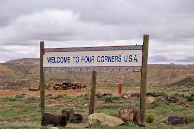
Four Corners USA UT-CO-NM-AZ


The Four Corners Monument marks the quadripoint in the Southwestern United States where the states of Arizona, Colorado, New Mexico, and Utah meet.


 It is the only point in the United States shared by four states, leading to this area's being called the Four Corners region.


The origins of the state boundaries marked by the monument occurred just prior to, and during, the American Civil War, when the United States Congress acted to form governments in the area to combat the spread of slavery to the region.


The monument consists of a granite disk embedded with a smaller bronze disk around the point, surrounded by smaller, appropriately located state seals and flags representing both the states and tribal nations of the area. Circling the point, starting from north, the disk reads with two words in each state "Here meet in freedom under God four states"


I am standing in Colorado. Go Rockies!


Kathy's hands are located in Colorado and Utah.  Her feet are in New Mexico and Utah.  I would say she gets around!

Friday, May 15, 2015

Mesa Verde National Park Colorado - Wethermill Mesa

Welcome to a quieter side of Mesa Verde National Park.  Wethermill Meas offers easy bicycle rides (bring your own) and short hiking trail to archaeological sites and scenic overlooks. 


Its a 28 mile long winding drive to the parking lot at the end of Wethermill Mesa road.  


The path around the Long House Loop is 5 miles. We decided to visit Nordenskiold #16, Badger House and the Long House Overlook which is just short of 4 miles round trip.


It was windy, chilly and beginning to rain.  Kathy was prepared with gloves and her ear warmers.  


Here is the trail marker for Nordenskiold #16.  


This is the first view of the pueblo as we approach the site. 


The Nordenskiold #16 cliff dwellings are interesting because the cliff has sort of a double alcove that the ancient architects took advantage of to make two levels of structures. The ruins are far enough away that a pair of binoculars or a telephoto lens are needed to see them well. This photo was taken with maximum zoom on our camera.


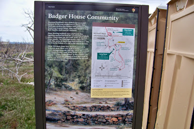
Trail Marker for the Badger House Community.  


They do have wild horses in the park as evidenced in this photo.  We did see a lot of evidence but no horses. 


About 1,400 years ago, long before Europeans explored North America, a group of people living in the Four Corners region chose Mesa Verde for their home. For more than 700 years they and their descendants lived and flourished here, eventually building elaborate stone communities in the sheltered alcoves of the canyon walls.


The Badger House Community consists of several sites dating from about A.D. 650 to the late 1200s. There are four sites along a paved and gravel walking trail. These homes were built one stone thick with a wood mud roofs. 


Pueblo Village was considered one of the first communities in Mesa Verde. 


You can see here that the site was covered with a metal framed building to help preserve the site for future generations. The framing was such that metal windows would slide close during winter months to keep out the elements.


Over time masonry replaced Adobe style walls and central villages came to dominate smaller subordinate ones scattered around them in multi-village polities.


This Kiva used for religious ceremonies and other gatherings.  


This photo shows the depth of the Kiva.


You can see here that two Kivas were built for this community.


Here you can see the changes from a one wall construction to a two wall construction formation. 


This era also resulted in the introduction of pottery, which reduced the number of baskets that they made and eliminated the creation of woven bags. The simple, gray pottery allowed them a better tool for cooking and storage.


Long House is considered the second largest cliff dwelling in the park. The sheer beauty of the site makes the trip out to Wetherill Mesa worth the time and effort. 


You can see in this photo a ranger and visitor are visiting this site.  We did see them leave from the parking lot before we started our hike but did not know where they were headed. 


The watch tower was believed to be used for communicating between villages or between farms and villages or possibly keeping an eye on your enemy. 


Can you see the watch tower in this photo?


Photo enlarged for viewing.  Most pueblos site also had a watch tower. One of the most famous is located in Cliff Palace. 

Kathy and I both enjoyed our trip to Mesa Verde National Park.  Had we known the beauty of this park we would have certainly made an effort to visit Mesa Verde on our previous trips west.  It is a little out of the way but well worth the effort it takes to get here.


Pulling up Anchor at Acadia National Park

 I thought it would be nice to add a few facts about Acadia National in each of the photos below. We decided that our last trip here at Acad...