Sunday, May 31, 2015

Capitol Reef National Park - Capitol Gorge & Narrows


The Capitol Gorge Trailhead is at the southern end of Scenic Drive.  You drive 10 miles down the road to reach the turn off. 


After driving another 2-1/4 miles down a dirt road you reach the parking lot and the beginning of the trail. 


A stroll down the wash takes you through what once was a wagon road and subsequently a route used by motor vehicles before the construction of UT-24 in 1962.  Creating and maintaining the old road was a demanding effort for the early settlers of the area. 


You can see how high the cliffs are on each side of the wash.


The Gorge gets smaller at one portion of the hike. 


We finally arrive at the Trail Marker.  


From the sign, the trails ascends through a jumble of boulders with unexpected twists and turns marked by cairns.


After making a quick climb, the trail levels out. 


The spur hike to The Tanks is 0.2 miles. 


Some of the water pockets are filled with water only in the spring or after a heavy rainstorm. 


Some of the larger tanks always have water, 


This area leads to a couple of smaller tanks.  All these potholes are essential sources of water for wildlife in the area. 


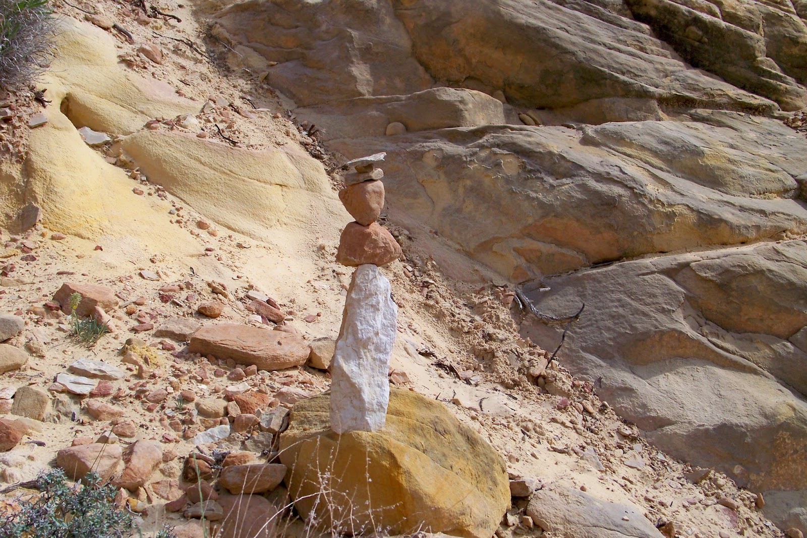
Here's a photo of an interesting cairn showing the way.


While driving back out on the Scenic Drive, we took some of the best pictures of the park.


Here's another great photo of the park.

The Narrows


This hike can be tackled in several ways, as a round trip from either the Grand Wash Trailhed or the UT24 trailhead, or an in and out.  We decided to make it a shorter hike and the fastest way to access the narrows. 


From the elevated Grand Wash parking area, the trail stays above the wash for 0.1 miles and then drops into the wash. 


This is Capitol Reef rendition of the "Chia pet."


We find another good opportunity for a photo.


After passing a rocky section the route enters Navajo Sandstone.  


You can see how the height of the canyon walls. 


The narrow begins as the walls are separated by a spread of only 16feet.


We decided that after reaching the Trailhead for the Cassidy Arch, we would return to the parking lot. 


Hey buddy, Don't step back.


Grand Wash was created by water flowing through this fissure in the Waterpocket Fold, and the scouring of the canyon walls is clearly evident and quite impressive. 


A rock with a hole in the center. 


Capitol Reef National Park - The Valley of Cathedrals


Today we decided to take a ride outside the park called the Valley of Cathedrals.


We rented a Jeep Liberty for our 69 mile journey.  


Normally dry, Caineville Wash receives a small amount of perennial seepage water at Willow Seep.  Precious for livestock. 


You can see here the road is dirt bound and can become inaccessible during thunder storms.  


Marker for Temple of the Sun & Moon.  


Temple of the Sun a majestic free-standing butte that rises almost sheer from the valley floor to a height above 400 feet,  


A shirt distance from the Temple of the Sun is Glass Mountain, a curious mound of large selenite crystals. Selenite is Gypsum in the form of glassy crystals, its name means "moonstone." 


The road passes beside the clean-cut, vertical edge of a high bluff of Entrda sandstone called "Layercake Wall." The sheer face of the bluff displays numerous evenly bedded, varicolored layers of soft rock. 


The view of the Layercake Wall from inside our vehicle. 


 The intriguing layers of dark lava that can be seen from the roads in this vicinity are know as dikes and sills. 


We reach the marker for Gypsum Sinkhole. 


This sinkhole is a cylindrical pit about 50 feet in diameter, with sheer or overhanging walls.  At one time the pit was thought to be caused by a meteorite. Later studies led to the conclusion that it was created by the dissolving and draining away in the gypsum underlying Carmel formation.  Several years ago a party explored the sinkhole with ropes descending to 200 feet beneath the rim.


Cathedral Valley Junction routing point. 


Just Beautiful!


This shows our trail heading up out of the canyon.  


The Leslie Morrell Line Cabin and Corral are located in the Cathedral Valley section of northern Capitol Reef National Park in Utah. The cabin was built in the 1920s on Lake Creek by Paul Christensen at his sawmill as a summer residence for Christensen and his family. Christensen sold the cabin to Leslie H. Morrell around 1935, who took the cabin apart and rebuilt it at its present site for use as a winter camp for cowboys on the Morrell ranch. The use continued until 1970 when the area was sold to the National Park Service. It is one of the best-preserved relics of ranching activities in the park.


We have 29 more miles to travel. 


A view of the Upper Cathedral Valley.


Little did I know I was witnessing my first cattle round-up. 


Two cowboys and three dogs herd the cattle up the road.


You can see a better picture of the cowboys in this photo.  I was amazed how easily they herded the cattle.   


Every park has a balanced rock and we found ours. 


We decided we would take the short 1/4 mile hike to the Lower South Desert Overlook.


It's me.  Now where did I leave the jeep?


The overlook is on top of a line of high cliffs. 400 feet above the valley floor.


We decided to call this "Rings of Saturn" 


The Fremont River is rarely more than a foot deep but today we estimated that it was 
about 1-1/2 to 2 feet in deep.  Four wheel drive though not always necessary was a welcome relief to us.  We know we would have not made the drive in the mini-van.  The drive took us some six hours in total.  

Capitol Reef National Park - Cassidy Arch


The Cassidy Arch Trail starts at the Grand Wash. Cassidy Arch is a must hike for visitors. 


During our hike we found this hollowed out rock and thought what a great place for a picture.


The trail starts from the wash and travels 3.3 miles out and back.


Here the spur trail marker. This trail was named after Butch Cassidy, who reportedly had a hide out here, the trail is custom made for a bank robber trying to avoid the law. 


You start out with your boots in the sand and then quickly make a surprise breakout onto cliff switchbacks. 


This shows the trail beginning up the switchbacks.


Some of the trail is close to the edge as seen in this photo.


You gaze down the wash and road from a vantage point shared by big horn sheep and the elusive mountain lion. We saw neither of the two during our hike. 


Finally, near the arch, the trail disappears and becomes just a rolling route over barren slick rock. 


Then the arch instantly appears in full view.


From this photo, we are still .5 miles to the arch.


We finally arrive at the arch.


Here I am,  but wait.....


Click on this photo and that's stupid me out on top of the arch.  They did say it was safe to walk across the arch.  I think!


This shows the 2.4 mile dirt road that you have to drive to get to the parking lot where the hike begins. 


O.K. use your imagination.  This looks like the face of a gorilla with the nose, eyes and mouth angled to the side.  Maybe in need more water....

Pulling up Anchor at Acadia National Park

 I thought it would be nice to add a few facts about Acadia National in each of the photos below. We decided that our last trip here at Acad...